

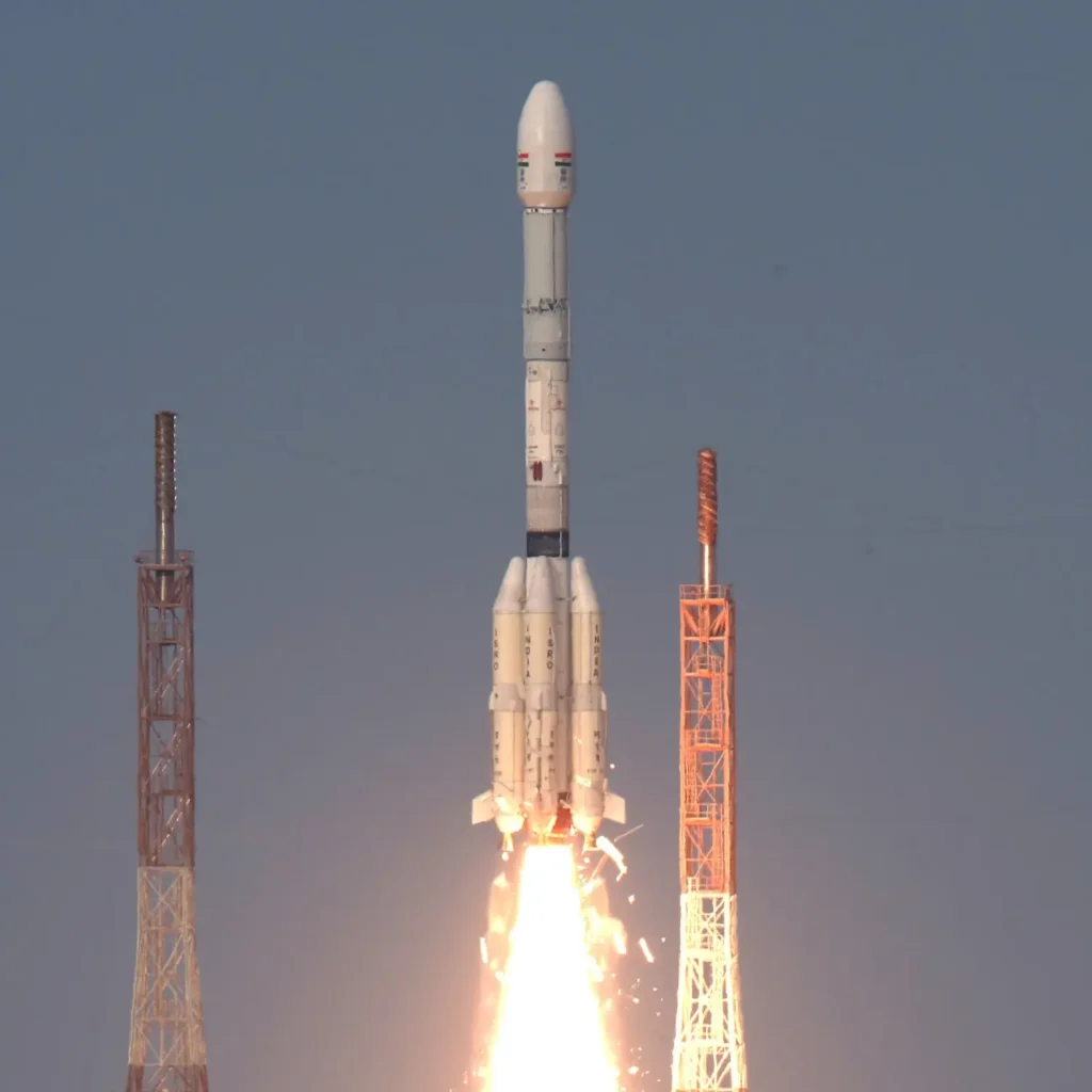
India has achieved a major milestone in space technology. The Indian Space Research Organisation (ISRO) successfully launched EOS-05, the country’s first dedicated imaging satellite designed to operate from a geosynchronous orbit. The satellite was launched aboard the GSLV-F17 rocket from the Satish Dhawan Space Centre in Sriharikota, Andhra Pradesh, at 2:55 am on September 04, 2026. About 18 minutes after liftoff, EOS-05 was placed into its planned Sub-Geosynchronous Transfer Orbit.
What is EOS-05?
EOS-05 is an Earth observation satellite. Its job is to look at Earth from space and capture images that can help scientists and authorities understand what is happening on the ground. What makes EOS-05 special is where it is designed to operate. It will eventually move to a geosynchronous orbit about 36,000 kilometres above Earth. At this height, its movement matches Earth’s rotation, allowing it to keep watching the same broad region for long periods.
Think of it as having a camera in the sky that can repeatedly look at the same part of Earth instead of passing over it only occasionally.
Why is this launch important?
India already has several Earth observation satellites. However, many of them operate in lower orbits and pass over a particular location at intervals. EOS-05 is different. From its much higher geosynchronous orbit, it is designed to provide near real-time images of large areas at frequent intervals. This can be particularly useful when something on Earth is changing quickly.
The satellite can help with:
- Disaster management: Monitoring floods, forest fires and other natural disasters
- Weather monitoring: Tracking rapidly changing weather events
- Agriculture: Observing crops and changes in farmland
- Forestry: Monitoring forests and natural resources
- Water resources: Observing water bodies
- Infrastructure: Helping with planning and monitoring large areas
- National security: Providing useful information for strategic purposes
How does a geosynchronous satellite work?
Imagine standing on a giant merry-go-round and watching one particular house outside it. If you move around at the same speed as the merry-go-round, that house can appear to stay in the same position. A geosynchronous satellite works similarly. Its orbit is synchronised with Earth’s rotation, allowing it to repeatedly observe the same region.
EOS-05 was first placed in a Sub-Geosynchronous Transfer Orbit. It will then carry out orbit-raising manoeuvres before reaching its final geosynchronous orbit.
EOS-05 weighs about 2,367 kilograms, making it the heaviest satellite carried by a GSLV rocket so far. The mission was also the 19th flight of India’s Geosynchronous Satellite Launch Vehicle.
What does EOS-05 mean for India?
Satellites such as EOS-05 show how space technology can be useful far beyond space exploration. A satellite that can frequently observe a large part of India can provide valuable information when floods occur, weather systems develop, or changes in agriculture and forests need to be studied.
For scientists and decision-makers, getting fresh information quickly can make it easier to understand a situation and respond to it. EOS-05 is more than just another satellite launch. It gives India a new way to observe its land and surrounding regions from space.
With its ability to provide frequent images of large areas, the satellite is expected to strengthen India’s Earth observation capabilities and help turn information from space into useful action on Earth.
Fun fact: EOS-05 is also known as GISAT-1A. It belongs to the GISAT series of Earth observation satellites.
FAQs on ISRO’s EOS-05 Launch:
What is EOS-05?
EOS-05 is an Earth observation satellite developed by ISRO and designed to provide frequent images of large areas of Earth.
What is special about EOS-05?
It is India’s first dedicated imaging satellite designed to operate from a geosynchronous orbit.
When did ISRO launch EOS-05?
ISRO launched EOS-05 on September 04, 2026, at 2:55 am IST from Sriharikota.
Which rocket launched EOS-05?
EOS-05 was launched using the GSLV-F17 rocket.
What is a geosynchronous orbit?
It is an orbit where a satellite’s movement is synchronised with Earth’s rotation, allowing it to observe the same broad region repeatedly.
How high will EOS-05 orbit above Earth?
EOS-05 is designed to operate at an altitude of roughly 36,000 kilometres above Earth.
What will EOS-05 be used for?
It will provide information useful for agriculture, disaster management, weather monitoring, forestry, water resources and strategic applications.
How much does EOS-05 weigh?
EOS-05 weighs about 2,367 kilograms.
Why is the EOS-05 launch important for India?
It strengthens India’s ability to frequently observe large areas from space and marks a major step in the country’s Earth observation capabilities.
Is EOS-05 a weather satellite?
EOS-05 is an Earth observation satellite, not a dedicated weather satellite. However, its frequent imaging can help monitor weather-related events and natural disasters.
Also read about:
- Future Astronauts Wanted: ISRO Has A New Plan
- NASA Invites ISRO to Join Future Moon Base Programme
- 10 Indian Scientists Who Made History with Amazing Discoveries
- India’s Private Space Boost: ‘Drishti’ Satellite Launched
- From Classroom to Cosmos: ISRO Launches Space Programme YUVIKA 2026 for Students
- Shubhanshu Shukla Becomes India’s Longest-Staying Astronaut in Space
Also, learn all about space with the All About Space Flash Cards!
Subscribe to The Junior Age Newspaper – click here. Know more fun facts on The Junior Age’s YouTube!